How to Track Tides and Plan Your Day Around the Reversing Falls

Why Do Saint John Locals Plan Their Commutes Around Water?
You're driving across the Harbour Bridge at 8:15 a.m., coffee in hand, when traffic slows to a crawl. Tourists with cameras line the railings. A cruise ship horn echoes from the terminal below. You check your watch and mutter—it's high tide. In Saint John, the Bay of Fundy doesn't just shape our coastline; it dictates our daily rhythms, influences our fishing industry, and determines whether that morning kayak paddle through the harbour is a leisurely drift or a battle against one of the world's most powerful tidal currents. Understanding how to read tide tables and plan your activities around them isn't just practical knowledge—it's a survival skill for anyone who works, plays, or commutes near the water in our port city.
Where Can I Find Reliable Tide Charts for Saint John?
The most accurate source for Saint John tide predictions comes from the Fisheries and Oceans Canada tide tables, which publishes data specifically for the Saint John Harbour station. You'll want to bookmark this page—it's updated daily and provides precise times for high and low tides, plus the height differentials that tell you just how dramatic the swing will be.
Local fishermen and harbour workers often rely on printed tide calendars available at J.D. Irving Shipbuilding's visitor centre on the west side, or at Brunswick Dock on Water Street. These pocket-sized guides show the entire year's tides at a glance—handy when you're planning a weekend boat launch from the Saint John Marina or scheduling a shift at one of the port terminals. Smartphone apps like Tides Near Me work reasonably well, but double-check them against the official Canadian data; Bay of Fundy tides behave differently than the algorithms sometimes predict.
Here's what the numbers mean: a typical tide cycle in Saint John spans about 12 hours and 25 minutes, with two high tides and two low tides each day. The range—the difference between high and low—averages around 8 metres (26 feet), though spring tides (during full and new moons) can push that past 9 metres. That volume of water moving through the narrow gorge at Reversing Falls creates currents reaching 12 knots—faster than most recreational boats can handle.
How Can I Time My Activities with the Tides?
Morning routines in our community often revolve around tidal patterns. If you're launching a small boat from the South End boat ramp near Fort Howe, aim for the slack tide—that 20- to 30-minute window when the water changes direction and the current momentarily stops. High tide brings deeper water for larger vessels at the public docks, but it also means less beach to walk along Tucker Park in the South End. Low tide exposes the mudflats near the Port of Saint John, which attracts shorebirds but makes launching anything larger than a kayak nearly impossible.
Commuters who cross the Harbour Bridge or use the Golden Ball Building area should know that high tide often coincides with heavier traffic—cruise ship arrivals, tour buses heading to Reversing Falls, and waterfront workers starting shifts all converge at these peak times. If you've got flexibility, plan your crossing 30 minutes before or after the posted high tide time to avoid the bottleneck.
For recreational activities, the timing matters even more. Kayakers wanting to paddle through the gorge at Reversing Falls should only attempt this at slack tide—and even then, with experienced guides from local outfitters. The rest of the time, that current will pin you against the rocks or sweep you toward the bay faster than you can paddle back. Conversely, if you're beachcombing along the Bay of Fundy coastline near Mispec Beach or Red Head, low tide is your friend—it exposes tide pools, reveals agates and interesting rocks, and gives you three hours of walking territory that disappears completely when the water returns.
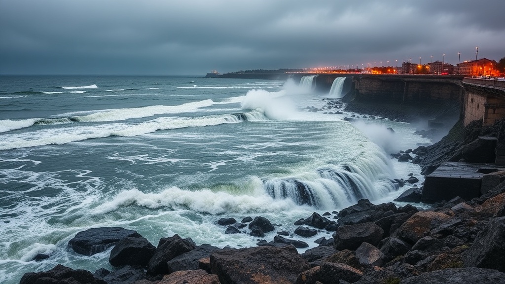
What Should I Know About the Reversing Falls Rapids?
The Reversing Falls isn't technically a waterfall—it's a series of rapids and whirlpools created when the rising tide from the Bay of Fundy meets the outflowing Saint John River. At low tide, the river rushes through the narrow gorge toward the bay. At high tide, the bay's superior water level pushes back, reversing the flow. The transition period—slack tide—creates an illusion of calm that disappears quickly.
The Reversing Falls Bridge and the Skywalk Saint John offer the safest viewing, but locals know the best perspective comes from the Waterfront Trail that runs from the harbour up toward the falls. This paved path connects several neighbourhoods—Indiantown, the Lower West Side, and Millidgeville—giving residents a car-free route that doubles as a tide-watching corridor. Benches along the trail mark spots where you can sit and watch fishing boats time their passage through the gorge, waiting for that precise moment when the water goes slack.
Industrial traffic follows these same rules. The massive vessels that service Irving Pulp & Paper and the oil terminals on the east side schedule their movements around tidal windows. When you see a cargo ship passing under the Harbour Bridge at 3 a.m., it's not random—they're hitting the precise tide that gives them enough clearance and manageable current to safely reach their berths at the Port of Saint John terminals.
How Do Tides Affect Saint John's Waterfront Events and Access?
Our community's relationship with the water extends beyond practical concerns. The Saint John City Market vendors—particularly the fishmongers on the lower level—plan their wholesale purchases around tidal fishing schedules. Fresh catch arrives daily, but the volume and species vary based on when boats could safely return to harbour. If you're buying seafood for a weekend dinner, Friday afternoon typically offers the best selection; Monday mornings can be slim if weekend tides prevented boats from heading out.
Events along the waterfront also contend with tidal realities. The Saint John Waterfront Cruise Pavilion hosts concerts and festivals throughout the summer, and organizers always check tide tables when scheduling load-in and load-out. Heavy equipment can't access certain areas during high tide, and the floating docks at the marina need adjustment as the water level changes. Even the Saint John Police Force marine unit plans patrols around tidal patterns—shallow areas at low tide become hazards, while high tide brings recreational boaters into the harbour who might need assistance.
Residents living in flood-prone areas—parts of Indiantown, Lowertown, and along Sandy Point Road—keep close eyes on storm surge warnings, which compound normal tidal heights. When a nor'easter hits during a spring high tide, basements flood and roads close. The city's emergency services coordinate with Environment Canada to issue warnings, but knowing your local tide schedule helps you anticipate problems before official alerts arrive.
Can I Predict When the Best Viewing Times Will Be?
Yes—and locals have been doing it for generations. The most dramatic Reversing Falls viewing happens during the hour before and after the tide changes. You'll see the churning water, the standing waves, and the whirlpools that give the rapids their dangerous reputation. The Skywalk's glass platform extends over the gorge, offering a perspective that shows just how violent that water movement becomes. But the free viewing platforms at Fallsview Park provide nearly as good a vantage point, with interpretive signs explaining the geology and history.
For photographers, the combination of tidal action and golden hour light creates striking images—if you time it right. Check the tide tables against sunrise and sunset times. A high tide at dawn in winter, with ice forming on the rocks, produces scenes you won't find in any other Canadian city. Summer evenings bring a different character—fishing boats returning home, their navigation lights cutting through the dusk, timing their passage through the gorge with practiced precision.
Living in Saint John means accepting that the water controls more than we sometimes realize. It determines when the ferries run to Digby and Grand Manan, when the fishing fleet departs from Simons Cove, and whether your waterfront property insurance premiums stay reasonable. But it also gives us one of the most dynamic, ever-changing waterfronts in the world—a natural phenomenon that happens in our backyard twice daily, free to watch, and endlessly fascinating once you learn to read its rhythms.